On October 10, 2024, the AdaptcCCDR team, together with local actors, carried out the first installation of environmental sensors in Bayahibe. This initiative marks a milestone in climate monitoring in the region, providing real data on air quality and atmospheric conditions. With this information, the aim is to improve the understanding of the effects of climate change and the generation of evidence-based strategies to mitigate its impact.
Measuring Climate Change in Real Time: Goals and Beneficiaries
The main objective of the installation of sensors is to allow real-time monitoring of the air, measuring parameters such as temperature, atmospheric pressure and concentration of microscopic particles. Thanks to updates every 10 minutes, these sensors provide key data to face climate change and protect the health of the community.
Industries that can benefit from these sensors include:
- Public Health: To monitor air quality and its impact on respiratory diseases.
- Construction: To design more resilient infrastructures.
- Education: To teach about sustainability and climate change in local schools.
- Local government: For better urban planning based on scientific data.
- Agriculture and fisheries: To adapt practices to changes in temperature and climatic conditions.
Sensor Installation: A Strategic and Complex Process
During the visit, the installation campaign was handled by carrying out the following steps:
- Placement of the sensors at the pre-selected points of the study area.
- Installation of base stations in the agreed locations. The base stations were located in protected public buildings, following the following criteria:
- Relative closeness between sensors.
- Ease of access.
- Sensor Safety and Integrity
Based on this, finally the selected locations were: Bayahibe High School, Bayahibe Elementary School, Bayahibe Fire Station
- Verification of successful data transmission to the cloud.
Since the installation required agreements with local actors and collaboration from related companies, the team considers that it was a relatively complex process, but not impossible.
Sensors and Their Technology: Capturing Information from the Environment
The AdaptccDR project currently uses two types of sensors:
- Carbon dioxide (CO2), temperature and pressure sensors.
- Particulate matter sensors (PM1, PM2.5, PM10).
As mentioned above, the sensors collect data every 10 minutes and send the measurements to base stations, which then transmit the information to the Aranet cloud. These data are used by the research team and will serve as input for the development of a digital twin model, which will allow simulations to be carried out on the environmental conditions of the area.
Reports with key statistics are generated monthly, which are published in the project’s RSS feeds.
Real-Time Monitoring Map: Visualizing the Impact
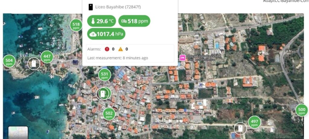
The Aranet cloud allows the location of the sensors to be visualized on a map. On the map, each green icon represents a sensor and shows the latest measurement of CO2 in particulate matter per million (ppm). When you position the cursor over a sensor, a file is displayed with the data recorded in the last 10 minutes.

On the map you can see, highlighted in green, the points where the CO2, temperature, pressure and particulate matter sensors are located. Each green icon indicates the last measurement of CO2 in particulate matter per million (ppm) recorded by the corresponding sensor.
In addition, when positioning the cursor over any of the sensors, a detailed information sheet is displayed with the values recorded in the last ten minutes, allowing real-time monitoring of environmental conditions.
Data Access: Towards a Transparent and Accessible Platform
One of the objectives of the project is the creation of a web portal that allows the visualization of the collected data in real time. This portal will include a dashboard with summaries and analysis of the monitored data.
In addition, preliminary data have revealed interesting patterns that need to be corroborated with other analyses within the project, such as the development of the digital twin model. Some of these patterns include:
- In certain points, such as the Environment area, temperatures of up to 40°C have been recorded on sunny days, despite being in the winter season. This is suspected to be due to the presence of stone and concrete surfaces in the area.
- In the area of the Manantial (El Hoyo), temperatures drop from noon, probably due to the high vegetation cover and the type of pavement in the area.
A Project That Drives Change, the next step.
In conclusion, the installation of sensors in Bayahibe provides fundamental data for scientific research and decision-making in key sectors. Now, the next step is to integrate this information into simulation models and web visualization tools, which will not only strengthen the capacity to adapt to climate change, but also contribute to improving the quality of life of the community.
In addition, this verified data source can be of great use to various sectors, from small and large companies to students, teachers and researchers. By consolidating itself as a reliable information base, it facilitates more accurate and informed decision-making on sustainability and climate change, promoting more efficient and effective strategies to face the environmental challenges of the future.
